| Home Page | Buying | Maps | Books | Prints | Ephemera |
- Home Page
- England & Wales County Maps Anglesea - Dorset
- England & Wales County Maps Durham - Merioneth
- England & Wales County Maps Midd'x - Somerset
- England & Wales County Maps Staffs - Yorks
- British Isles: Physical, Railways, Statistical, etc. Roman Britain
- England & Wales, Countries, Islands, Regions inc. the Lake District, Road & Rail Maps
- Scotland, the Country & Regions: Town Plans & Environs; Rail Maps
- Ireland, the Country, Regions & Environs
- England & Wales, Town Plans & Maps of Environs
- Ordnance Survey and Folding Maps

There are 10 pages of maps of the British Isles. Please see the index on the Great Britain page to gain access to 1000 maps of England, Wales, Scotland and Ireland.
All our maps are Originals, NOT modern reproductions and have thumbnails as well as larger images so it is easy to find what you are looking for.
If you want several items, email me for a discount!
Email: don@theoldmapman.com
> Section 1 > Section 2 > Section 3
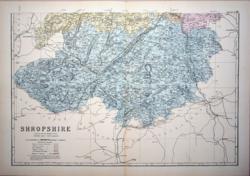
 Shropshire Hughes for Virtue & Co. 1873 - 24 x 31 cm Colour printed map of the county showing roads and railways. The Divisions in different colours. Unfolded. Small ink smear in Montgomery. Larger image Ref uk437 : £3 Return to Great Britain & Ireland Index |
 Shropshire Hughes for Virtue & Co. 1868 - 24 x 31 cm Colour printed map of the county showing roads and railways. Larger image Ref uk438 : £4 Return to Great Britain & Ireland Index |
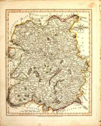
 Shropshire John Cary 1787 - 21 x 27 cm Antique map with original hand colouring of roads, woodland and the county boundaries. One margin is narrow, (see image). Supplied with a separate sheet describing the county and its industry, farming, gentry and environment, together with a list of the country seats and The most remarkable Places for extensive Prospects, etc. Larger image Ref uk1299 : £24 Return to Great Britain & Ireland Index |
 Shropshire John Cary 1809 - 22 x 27 cm From New English Atlas. Contemporary hand colouring. Couple of small stains. Some darkening of outline green wash Larger image Ref uk161 : £20 Return to Great Britain & Ireland Index |
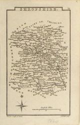 Shropshire Leigh/Hall c 1820 - 7 x 12 cm Neat and clean uncoloured map of the County. Full of detail. Larger image Ref uk782 : £11 Return to Great Britain & Ireland Index |
 Shropshire Seller-Grose 1773/87 - 15 x 12 cm Uncoloured early map on half page with text below and verso Larger image Ref uk039 : £20 Return to Great Britain & Ireland Index |
 Shropshire Thomas Moule c1845 - 28 x 22 cm Decorative map with vignettes and coats of arms. Uncoloured as issued. As is often the case with these maps there are several original folds. Some very light foxing along a fold (see image). Several railways are shown. Larger image Ref uk1067 : £14 Return to Great Britain & Ireland Index |
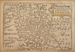 Shropshire van den Keere 1627-46 - 12 x 8 cm Uncoloured copy on slightly toned paper. The impression is a bold one which suggests an earlier edition as the plates became quite worn and although re-worked they were not replaced, finally being used in 1676. English text verso. The earlier use of sellotape fortunately will not be shown when mounted. (See images). An inexpensive copy. Larger image 1 : Larger Image 2 : Larger Image 3 Ref uk1149 : £45 Return to Great Britain & Ireland Index |
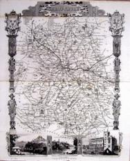
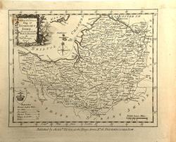
 Shropshire North G W Bacon c 1885 - 46 x 30 cm Large double page hand coloured map as issued showing woods, parks, hills, roads and railways together with towns, villages and hamlets and even individual properties. The railway network is very clearly shown and the railway companies are named on each line. A very attractive map in fine condition. Larger image Ref uk953 : £13 Return to Great Britain & Ireland Index |
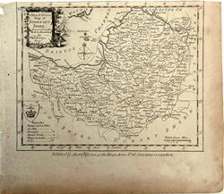
 Shropshire South G W Bacon c 1885 - 46 x 30 cm Large double page hand coloured map as issued showing woods, parks, hills, roads and railways together with towns, villages and hamlets and even individual properties. The railway network is very clearly shown and the railway companies are named on each line. A very attractive map in very good condition. (Short crease at foot of centrefold) Larger image Ref uk954 : £13 Return to Great Britain & Ireland Index |
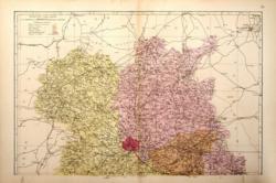 Shropshire: 2 sheets G W Bacon 1881 - 46 x 61 cm Large double page hand coloured map as issued with woods, parks, hills, roads and railways. The railway companies are named on each line. Mount together to form one large map. Two edge tears, closed. Bottom 2 or 3 cm of each sheet split at centrefold and repaired. When mounted and framed would not be very noticeable. Two images available. Larger image 1 : Larger Image 2 Ref uk528 : £8 Return to Great Britain & Ireland Index |
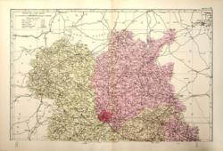
 Shropshire: 2 sheets G W Bacon 1887 - 46 x 61 cm Large double page hand coloured map as issued with woods, parks, hills, roads and railways. The railway companies are named on each line. Mount together to form one large map. Bottom 2 or 3 cm of South sheet split on centrefold and repaired. When mounted and framed would not be noticeable. Otherwise very nice copies. Two images available. Larger image 1 : Larger Image 2 Ref uk529 : £12 Return to Great Britain & Ireland Index |
 Shropshire: 2 sheets G W Bacon 1890 - 46 x 61 cm Large double page hand coloured map as issued with woods, parks, hills, roads and railways. The railway companies are named on each line. Mount together to form one large map. South sheet has what appear to be old glue spots in the bottom LH corner, outside the Shropshire border which mar an otherwise fine pair of sheets. Two images available. Larger image 1 : Larger Image 2 Ref uk530 : £14 Return to Great Britain & Ireland Index |
 Shropshire: 2 sheets G W Bacon 1898 - 46 x 61 cm Large double page coloured map with woods, parks, hills, roads and railways. The railway companies are named on each line. Mount together to form one large map. Some foxing around edges but will look fine in a mount. Two images available. Larger image 1 : Larger Image 2 Ref uk531 : £12 Return to Great Britain & Ireland Index |
 Somerset Archer for Dugdale 1850 - 24 x 18 cm Very fine outline hand colouring of the County and Hundred boundaries as well as the railways which are a feature of these attractive maps Larger image Ref uk329 : £10 Return to Great Britain & Ireland Index |
 Somerset Cole/Roper 1807 - 23 x 18 cm A very fine map of the county, hand-coloured in outline as issued. Larger image Ref uk779 : £22 Return to Great Britain & Ireland Index |
 Somerset Drawn & engraved by J. Archer, Pentonville, London for Dugdale's England and Wales Delineated. c1850 - 23 x 18 cm Uncoloured map of the County and Hundred boundaries as well as the railways which are a feature of these attractive maps. Centrefold as issued. Larger image Ref uk1657 : £10 Return to Great Britain & Ireland Index |
 Somerset J & C Walker 1837 - 39 x 32 cm Fine original hand colouring of the hundreds and the county boundaries. Good condition. See the image. Shows the Western Railway. Larger image Ref uk859 : £28 Return to Great Britain & Ireland Index |
 Somerset John Cary 1787 - 27 x 21 cm Antique map with original hand colouring of roads, woodland and the county boundaries. Ink stain at edge of lower margin. Supplied with a separate sheet describing the county and its industry, farming, gentry and environment, together with a list of the country seats and The most remarkable Places for extensive Prospects, etc. Larger image Ref uk1300 : £28 Return to Great Britain & Ireland Index |
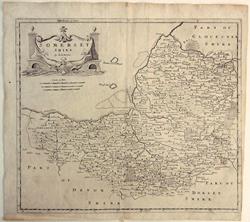 Somerset Robert Morden 1695/1772 - 41.5 x 36 cm Uncoloured map from Camden's Britannia. Centrefold and somewhat smoothed creases nearby. Right margin shaved to the edge of the engraved area as often the case with Mordens. (see image). The paper has a large cockerel watermark so far undated. Larger image Ref uk1641 : £45 Return to Great Britain & Ireland Index |
 Somerset Simmons, Jenner, van Langeren 1643 - 10 x 10 cm Engraved by Jacob Florensz Van Langeren and first published in A Direction for the English Traviller by which he shal be inabled to coast all about England and Wales... London, Matthew Simmons, 1635. The distance tables were copied from the inventor of the tables, John Norden who published them in his England: An Intended Guyde, For English Travailers... Invented & Collected By John Norden. London 1625. Matthew Simmons publication included the addition of small thumbnail maps of the counties which were copied from a set of playing cards by William Bowes in 1590. With fifty two counties in England and Wales a pack of playing cards presented a neat way of depicting each county. Simmons included compass directions after the place names on the table which gave an approximate location by referring to the thumbnail map. Simmons re-issued his work twice more in 1636, the second publication of this year included the addition of distances from London along the diagonal of the tables. Thomas Jenner published another version of the tables in 1643 with a slightly larger map, this time copied from the general map in John Speed's Theatre of the Empire of Great Britain London 1611. Small old repair to bottom margin. Very nice copy of a very scarce map. Centrefold as issued. Larger image Ref uk1632 : £55 Return to Great Britain & Ireland Index |
 Somersetshire Badeslade & Toms 1742 - 14.5 x 15 cm Uncoloured map of the county with a panel describing the towns and cities with market days, the rivers of the county and the numbers of MPs. Centrefold as issued. Dated in the plate. Very good condition. Larger image Ref uk1634 : £48 Return to Great Britain & Ireland Index |
 Somersetshire Dix; Darton c1835 - 43 x 35 cm This is one of the rarest of the large county maps. The Atlas was first issued in 1822. This map is from the later edition of the atlas, published c1835, for which imprint dates were removed from the maps, titles were changed and electoral information was added. With an engraving of Clare Street and the Draw Bridge, Bristol. In original hand colour, though some of the colour has oxidised. Shown in a mount but will be depatched rolled without card. Larger image 1 : Larger Image 2 Ref uk1643 : £125 Return to Great Britain & Ireland Index |
 Somersetshire James Pigot c1839 - 16.5 x 10.5 cm The smaller Pigot map of the county with original hand colouring as issued and with the facing page showing a Distance Table and a vignette of the West front of Wells cathedral. Attached is a 28pp section describing the towns and villages of the county and including tables of their populations and market days. Some spotting to the map and the opposite page. Larger image 1 : Larger Image 2 Ref uk1639 : £30 Return to Great Britain & Ireland Index |
 Somersetshire James Pigot, T Slater c1846/57 - 35.5 x 23 cm The larger Pigot map of the county showing much detail and with fine original hand colouring as issued and in very clean condition. Inset engraving of the West front of Wells cathedral. The left margin has some closed tears across it and each corner has been repaired following earlier pastings to a backing sheet. See image. Larger image Ref uk1640 : £35 Return to Great Britain & Ireland Index |
 Somersetshire Thos Bowen, Alex'r Hogg 1784 - 20 x 16.5 cm Very nice uncoloured eighteenth century map of the county. The top margin has been made by adding old paper as the map was divided from one above it along the edge of the engraved area. Larger image Ref uk1635 : £15 Return to Great Britain & Ireland Index |
 Somersetshire Thos Bowen, Alex'r Hogg 1784 - 20 x 16.5 cm Very nice uncoloured eighteenth century map of the county. There is no top margin as the map was divided from one above it along the edge of the engraved area. Larger image Ref uk1636 : £12 Return to Great Britain & Ireland Index |
 Somersetshire & Staffordshire John Cary 1792 - 10.5 x 16 cm Antique double sided maps from The Traveller's Companion, with original fine hand colouring of boundaries, roads, towns & parks. Larger image 1 : Larger Image 2 Ref uk1847 : £18 Return to Great Britain & Ireland Index |
> Section 1 > Section 2 > Section 3 | |||