| Home Page | Buying | Maps | Books | Prints | Ephemera |
- Home Page
- England & Wales County Maps Anglesea - Dorset
- England & Wales County Maps Durham - Merioneth
- England & Wales County Maps Midd'x - Somerset
- England & Wales County Maps Staffs - Yorks
- British Isles: Physical, Railways, Statistical, etc. Roman Britain
- England & Wales, Countries, Islands, Regions inc. the Lake District, Road & Rail Maps
- Scotland, the Country & Regions: Town Plans & Environs; Rail Maps
- Ireland, the Country, Regions & Environs
- England & Wales, Town Plans & Maps of Environs
- Ordnance Survey and Folding Maps

There are 10 pages of maps of the British Isles. Please see the index on the Great Britain page to gain access to 1000 maps of England, Wales, Scotland and Ireland.
All our maps are Originals, NOT modern reproductions and have thumbnails as well as larger images so it is easy to find what you are looking for.
If you want several items, email me for a discount!
Email: don@theoldmapman.com
> Section 1 > Section 2
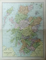 Scotland J Bartholomew, FRGS. Blackie & Son. c1895 - 22 x 29 cm Original antique coloured map showing the counties. Centrefold as issued. Larger image Ref uk1773 : £8 Return to Great Britain & Ireland Index |
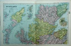 Scotland, North G W Bacon 1897 - 50 x 31 cm Large original antique coloured map. Centrefold as issued. Inserts of the Islands and Aberdeen. Larger image Ref uk1775 : £17 Return to Great Britain & Ireland Index |
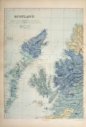 Scotland: 4 sheets G W Bacon 1890 - 32 x 44 each cm Insets of the Northern Isles and of the environs of Aberdeen, Dundee, Glasgow, Perth and Edinburgh. All in very nice condition. (Some hand colouring). Four images available. Larger image 1 : Larger Image 2 : Larger Image 3 : Larger Image 4 Ref uk739 : £20 Return to Great Britain & Ireland Index |
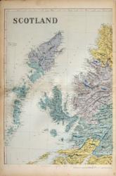 Scotland: 4 sheets G W Bacon 1887 - 32 x 44 each cm A fine and detailed large map of the country. The NE sheet has a short piece of transparent water based tape on the LH edge front and has its centrefold repaired and a small paint smudge on the sea. The SW sheet has its centrefold repaired and the SE sheet has a short piece of transparent water based tape on the LH edge front (see images). (Some hand colouring). Four images available. Larger image 1 : Larger Image 2 : Larger Image 3 : Larger Image 4 Ref uk742 : £12 Return to Great Britain & Ireland Index |
 Scotland: Aberdeen From Black's Guide to Scotland 1901 - 21 x 26 cm Original antique engraved map. Several original folds. The little edge tears have been repaired. Larger image Ref uk1863 : £15 Return to Great Britain & Ireland Index |
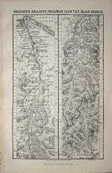 Scotland: Aberdeen, Ballater, Braemar, Glen Tilt, Blair Athole J Bartholomew 1879 - 9 x 14.5 cm For A & C Black's Picturesque Tourist of Scotland Larger image Ref uk1381 : £4 Return to Great Britain & Ireland Index |
 Scotland: Aberdeen, Banff, Elgin, etc. From Black's Guide to Scotland 1901 - 22 x 16.5 cm Original antique coloured map. Two original folds. Larger image Ref uk1881 : £6 Return to Great Britain & Ireland Index |
 Scotland: Arisaig, Loch Eil, etc. From Black's Guide to Scotland 1901 - 16.5 x 11 cm Original antique coloured map. Larger image Ref uk1882 : £4 Return to Great Britain & Ireland Index |
 Scotland: Arran and the Lower Clyde From Black's Guide to Scotland 1901 - 34 x 16.5 cm Original antique coloured map. Three original folds. Larger image Ref uk1883 : £8 Return to Great Britain & Ireland Index |
 Scotland: Berwick-on-Tweed From Black's Guide to Scotland 1901 - 11 x 16.5 cm Original antique engraved map. Larger image Ref uk1864 : £8 Return to Great Britain & Ireland Index |
 Scotland: Bridge of Allan From Black's Guide to Scotland 1901 - 24.5 x 16.5 cm Original antique engraved map. Two original folds. Larger image Ref uk1865 : £7 Return to Great Britain & Ireland Index |
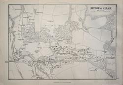 Scotland: Bridge of Allan J Bartholomew 1879 - 22 x 14.5 cm For A & C Black's Picturesque Tourist of Scotland. Two original folds. Larger image Ref uk1383 : £7 Return to Great Britain & Ireland Index |
 Scotland: Caithness From Black's Guide to Scotland 1901 - 11 x 16.5 cm Original antique coloured map. Larger image Ref uk1884 : £4 Return to Great Britain & Ireland Index |
 Scotland: Caledonian Canal From Black's Guide to Scotland 1901 - 35 x 16.5 cm Original antique coloured map. Three original folds. Larger image Ref uk1885 : £10 Return to Great Britain & Ireland Index |
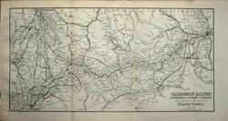 Scotland: Caledonian Railway: Edinburgh & Glasgow to Carlisle J Bartholomew 1879 - 28.5 x 14.5 cm For A & C Black's Picturesque Tourist of Scotland. Three original folds. Larger image Ref uk1367 : £9 Return to Great Britain & Ireland Index |
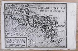 Scotland: Cathnes. Et. Orcades. I. (Cathanes and Orknay ins) van den Keere 1617 - 12 x 8.5 cm Original antique map with Latin text verso. Published by W J Blaeu. The map is signed Patrus Kaerius caela. Larger image Ref uk1825 : £54 Return to Great Britain & Ireland Index |
 Scotland: Clyde, River & Firth From Black's Guide to Scotland 1901 - 34 x 16.5 cm Original antique coloured map. Three original folds. Larger image Ref uk1886 : £9 Return to Great Britain & Ireland Index |
 Scotland: Crinan Canal, etc. From Black's Guide to Scotland 1901 - 11 x 16.5 cm Original antique coloured map. Larger image Ref uk1887 : £5 Return to Great Britain & Ireland Index |
 Scotland: Cromarty District From Black's Guide to Scotland 1901 - 21.5 x 16.5 cm Original antique coloured map. Two original folds. Larger image Ref uk1888 : £6 Return to Great Britain & Ireland Index |
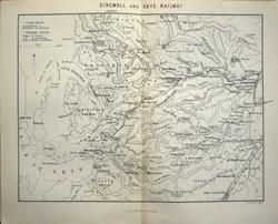
 Scotland: Dingwall & Skye Railway From Black's Guide to Scotland 1901 - 21 x 16.5 cm Original antique coloured map. Two original folds. Larger image Ref uk1889 : £7 Return to Great Britain & Ireland Index |
 Scotland: Dingwall & Skye Railway J Bartholomew 1879 - 18.5 x 14 cm For A & C Black's Picturesque Tourist of Scotland. Centrefold. Toning along centrefold. Larger image Ref uk1393 : £7 Return to Great Britain & Ireland Index |
 Scotland: Dundee From Black's Guide to Scotland 1901 - 27 x 16.5 cm Original antique engraved map. Two original folds. Larger image Ref uk1866 : £10 Return to Great Britain & Ireland Index |
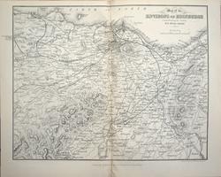
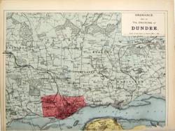 Scotland: Dundee Environs G W Bacon c 1887 - 31 x 22 cm Hand wash coloured map of the environs of the city as issued. Area covered: From Auchterhouse to Monikie and from Gallowfauld to Tay Port. The railway network is very clearly shown. There is no lower margin and an edge tear which has been repaired had crossed the border but is scarcely visible. Still a nice map. Larger image Ref uk616 : £9 Return to Great Britain & Ireland Index |
 Scotland: Dunkeld From Black's Guide to Scotland 1901 - 11 x 16.5 cm Original antique engraved map. Larger image Ref uk1867 : £7 Return to Great Britain & Ireland Index |
 Scotland: Edinburgh From Black's Guide to Scotland 1901 - 24 x 16.5 cm Original antique engraved map. Two original folds. Larger image Ref uk1868 : £12 Return to Great Britain & Ireland Index |
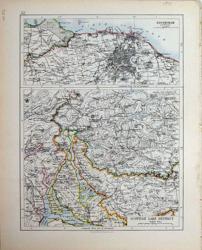 Scotland: Edinburgh and the Scottish Lakes. Verso: The South East. W & A K Johnston 1897 - 20 x 26 cm Edinburgh and Environs with a separate map of the Scottish Lake District on a scale of 6 miles to the inch. Verso: South East Scotland from St Andrews to the Solway Firth. Fine outline coloured maps. Two images available. Larger image 1 : Larger Image 2 Ref uk712 : £10 Return to Great Britain & Ireland Index |
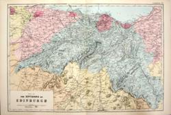 Scotland: Edinburgh Environs G W Bacon 1890 - 46 x 32 cm Hand wash coloured map of the environs of the city as issued. Includes Linlithgow and Musselburgh. Area covered: From Grahamston to Stow and St Andrews and from Dunsyre to Longniddry. The railway network is very clearly shown. Very fine condition. Larger image Ref uk618 : £14 Return to Great Britain & Ireland Index |
 Scotland: Edinburgh Environs, 10 miles around J Bartholomew 1879 - 18.5 x 14.5 cm For A & C Black's Picturesque Tourist of Scotland. Centrefold. Toning along centrefold. Larger image Ref uk1368 : £7 Return to Great Britain & Ireland Index |
 Scotland: Environs of Edinburgh From Black's Guide to Scotland 1901 - 25 x 16.5 cm Original antique coloured map. Two original folds. Larger image Ref uk1890 : £9 Return to Great Britain & Ireland Index |
 Scotland: Environs of Glasgow From Black's Guide to Scotland 1901 - 11 x 16.5 cm Original antique coloured map. Larger image Ref uk1896 : £6 Return to Great Britain & Ireland Index |
 Scotland: Fife & Kinross. North British Railway From Black's Guide to Scotland 1901 - 11 x 16.5 cm Original antique coloured map. Larger image Ref uk1892 : £5 Return to Great Britain & Ireland Index |
 Scotland: Fort William District From Black's Guide to Scotland 1901 - 27 x 16.5 cm Original antique coloured map. Two original folds. Larger image Ref uk1893 : £7 Return to Great Britain & Ireland Index |
 Scotland: Galloway From Black's Guide to Scotland 1901 - 22. x 16.5 cm Original antique coloured map. Two original folds. Larger image Ref uk1894 : £6 Return to Great Britain & Ireland Index |
 Scotland: Glasgow From Black's Guide to Scotland 1901 - 23 x 16.5 cm Original antique engraved map. Two original folds. Larger image Ref uk1870 : £12 Return to Great Britain & Ireland Index |
 Scotland: Glasgow Cathedral J Bartholomew 1879 - 8 x 14 cm For A & C Black's Picturesque Tourist of Scotland Larger image Ref uk1394 : £4 Return to Great Britain & Ireland Index |
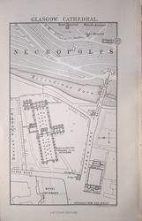
 Scotland: Glasgow Cathedral & Necropolis From Black's Guide to Scotland 1901 - 11 x 16.5 cm Original antique engraved map. Larger image Ref uk1871 : £4 Return to Great Britain & Ireland Index |
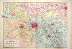 Scotland: Glasgow Environs G W Bacon 1890 - 47 x 31 cm Hand wash coloured map as issued with woods, parks, hills, roads and railways. Area covered: From Greenock to Falkirk and from Kilbirnie to Carluke. Very fine condition. Larger image Ref uk620 : £14 Return to Great Britain & Ireland Index |
 Scotland: Glasgow, Greenock, Kilmarnock & Ayr and Dumbartonshire Railways From Black's Guide to Scotland 1901 - 11 x 16.5 cm Original antique coloured map. Larger image Ref uk1897 : £4 Return to Great Britain & Ireland Index |
 Scotland: Glasgow. Hotel & Railway Chart From Black's Guide to Scotland 1901 - 11 x 16.5 cm Original antique engraved map. Supplied attached to 8pp Guide to the Glasgow Exhibition of 1901. Larger image Ref uk1869 : £10 Return to Great Britain & Ireland Index |
 Scotland: Glen Isla, Glen Shee, etc. From Black's Guide to Scotland 1901 - 16.5 x 11 cm Original antique coloured map. Larger image Ref uk1895 : £5 Return to Great Britain & Ireland Index |
 Scotland: Greenock From Black's Guide to Scotland 1901 - 11 x 16.5 cm Original antique engraved map. Larger image Ref uk1872 : £8 Return to Great Britain & Ireland Index |
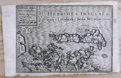 Scotland: Hebrides Insulae .. (The Iles of Hebrides wiz ther borderers) van den Keere 1617 - 12 x 8.5 cm Original antique map with Latin text verso. Published by W J Blaeu. The map is signed Patrus Kaerius caelavit. The map has some toning. Larger image Ref uk1824 : £54 Return to Great Britain & Ireland Index |
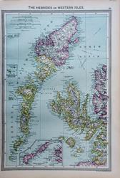 Scotland: Hebrides or Western Isles. Geo. Philip c1907 - 23 x 36 cm Large coloured map. Insets of Tiree & Coll and of St. Kilda. Larger image Ref uk1675 : £9 Return to Great Britain & Ireland Index |
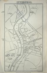
 Scotland: Inverness From Black's Guide to Scotland 1901 - 11 x 16.5 cm Original antique engraved map. Larger image Ref uk1873 : £8 Return to Great Britain & Ireland Index |
 Scotland: Inverness. Verso: The Caledonian Canal J Bartholomew 1879 - 9 x 16 cm For A & C Black's Picturesque Tourist of Scotland Larger image 1 : Larger Image 2 Ref uk1391 : £6 Return to Great Britain & Ireland Index |
 Scotland: Iona From Black's Guide to Scotland 1901 - 11 x 16.5 cm Original antique coloured map. Larger image Ref uk1899 : £6 Return to Great Britain & Ireland Index |
 Scotland: Jura, Colonsay, etc. From Black's Guide to Scotland 1901 - 23 x 16.5 cm Original antique coloured map. Two original folds. Larger image Ref uk1898 : £7 Return to Great Britain & Ireland Index |
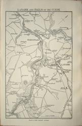 Scotland: Lanark & Falls of Clyde J Bartholomew 1879 - 9 x 14.5 cm For A & C Black's Picturesque Tourist of Scotland Larger image Ref uk1398 : £4 Return to Great Britain & Ireland Index |
> Section 1 > Section 2 | |||