| Home Page | Buying | Maps | Books | Prints | Ephemera |
- Home Page
- England & Wales County Maps Anglesea - Dorset
- England & Wales County Maps Durham - Merioneth
- England & Wales County Maps Midd'x - Somerset
- England & Wales County Maps Staffs - Yorks
- British Isles: Physical, Railways, Statistical, etc. Roman Britain
- England & Wales, Countries, Islands, Regions inc. the Lake District, Road & Rail Maps
- Scotland, the Country & Regions: Town Plans & Environs; Rail Maps
- Ireland, the Country, Regions & Environs
- England & Wales, Town Plans & Maps of Environs
- Ordnance Survey and Folding Maps

There are 10 pages of maps of the British Isles. Please see the index on the Great Britain page to gain access to 1000 maps of England, Wales, Scotland and Ireland.
All our maps are Originals, NOT modern reproductions and have thumbnails as well as larger images so it is easy to find what you are looking for.
If you want several items, email me for a discount!
Email: don@theoldmapman.com
> Section 1 > Section 2 > Section 3
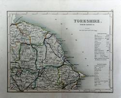
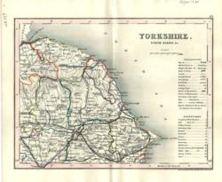
 Yorkshire, North Riding Hughes for Virtue & Co. 1868 - 31 x 24 cm Colour printed map of the county showing roads and railways. Some foxing. Centrefold strengthened. Larger image Ref uk450 : £3 Return to Great Britain & Ireland Index |
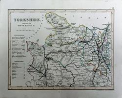
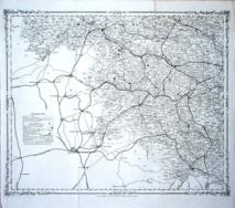
 Yorkshire, North Riding J & C Walker 1837 - 39 x 32 cm Fine original hand colouring of the hundreds and the county boundaries. Good condition. See the image. Shows the Pickering and Whitby Railway and the Stockton & Darlington. Larger image Ref uk870 : £26 Return to Great Britain & Ireland Index |
 Yorkshire, North Riding S.A.Oddy 1813 - 27 x 18 cm Good original wash colour of the hundreds Larger image Ref uk366 : £15 Return to Great Britain & Ireland Index |
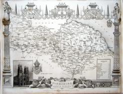
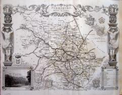
 Yorkshire, North Riding Thomas Moule c1845 - 28 x 22 cm Decorative map with vignettes and coats of arms. Uncoloured as issued. As is often the case with these maps there are several original folds. Several railways are shown. Larger image Ref uk1078 : £16 Return to Great Britain & Ireland Index |
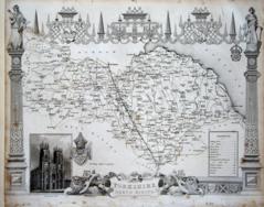
 Yorkshire, North Riding Thomas Moule c1845 - 28 x 22 cm Decorative map with vignettes and coats of arms. Uncoloured as issued. As is often the case with these maps the engraving reaches edges of the sheet where old paper extensions will make fitting it to a mount easier. A few faint spots of foxing. No railways are shown. Larger image Ref uk1116 : £14 Return to Great Britain & Ireland Index |
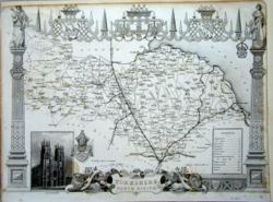
 Yorkshire, North Riding Thomas Moule c1845 - 28 x 22 cm Decorative map with vignettes and coats of arms. Uncoloured as issued. As is often the case with these maps the engraving reaches almost to an edge of the sheet where an old paper extension will make fitting it to a mount easier. A railway is shown. Closed edge tear abd a crease across a corner. Larger image Ref uk1119 : £10 Return to Great Britain & Ireland Index |
 Yorkshire, North Riding Thomas Moule c1845 - 28 x 22 cm Decorative map with vignettes and coats of arms. Uncoloured as issued. As is often the case with these maps the engraving reaches edges of the sheet where old paper extensions will make fitting it to a mount easier. A few faint spots of foxing. Several railways are shown. Larger image Ref uk1120 : £9 Return to Great Britain & Ireland Index |
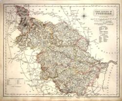
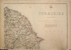
 Yorkshire, North Riding (East) Archer for Dugdale c1850 - 24 x 18 cm Very fine original outline hand colouring of the County and Hundred boundaries as well as the railways which are a feature of these attractive maps. Centrefold as issued. Very good condition. Larger image Ref uk1765 : £8 Return to Great Britain & Ireland Index |
 Yorkshire, North Riding (East) Archer for Dugdale 1850 - 24 x 18 cm Very fine outline hand colouring of the County and Hundred boundaries as well as the railways which are a feature of these attractive maps Larger image Ref uk337 : £8 Return to Great Britain & Ireland Index |
 Yorkshire, North Riding (West) Archer for Dugdale c1850 - 24 x 18 cm Very fine original outline hand colouring of the County and Hundred boundaries as well as the railways which are a feature of these attractive maps. Centrefold as issued. Very good condition. Larger image Ref uk1766 : £8 Return to Great Britain & Ireland Index |
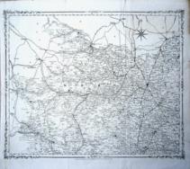 Yorkshire, NW H G Collins 1852 - 43 x 35 cm Large sheet of NW Yorkshire, uncoloured as issued with a fine decorated border all round. Original folds. A strong impression with railway lines and stations clearly marked. From The British Gazetteer. This sheet has had two lengthy tears professionally repaired so as to be quite unobtrusive within the area of the image. Larger image Ref uk1107 : £10 Return to Great Britain & Ireland Index |
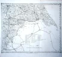 Yorkshire, SE H G Collins 1852 - 43 x 35 cm Large sheet of SE Yorkshire, uncoloured as issued with a fine decorated border all round. Original folds. A strong impression with railway lines and stations clearly marked. From The British Gazetteer. Larger image Ref uk1110 : £15 Return to Great Britain & Ireland Index |
 Yorkshire, SW H G Collins 1852 - 43 x 35 cm Large sheet of SW Yorkshire, uncoloured as issued with a fine decorated border all round. Original folds. A strong impression with railway lines and stations clearly marked. From The British Gazetteer. Larger image Ref uk1109 : £15 Return to Great Britain & Ireland Index |
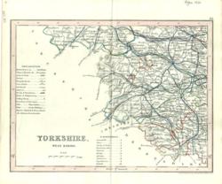
 Yorkshire, West Riding Geo. Philip & Son 1890 - 16 x 21 cm St Helens, Liverpool, Runcorn, Birkenhead. Manchester, Bolton, Rochdale, Oldham Larger image Ref uk118 : £8 Return to Great Britain & Ireland Index |
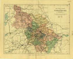 Yorkshire, West Riding Geo. Philip & Son 1889 - 20 x 15 cm Printed colour hundreds. Large number of railway lines. Larger image Ref uk656 : £7 Return to Great Britain & Ireland Index |
 Yorkshire, West Riding J & C Walker 1837 - 39 x 32 cm Fine original hand colouring of the hundreds and the county boundaries. Good condition. See the image. Shows the Leeds and Selby Railway. Larger image Ref uk869 : £28 Return to Great Britain & Ireland Index |
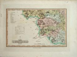 Yorkshire, West Riding S.A.Oddy 1813 - 27 x 18 cm Good original wash colour of the hundreds Larger image Ref uk365 : £15 Return to Great Britain & Ireland Index |
 Yorkshire, West Riding Thomas Moule c1845 - 28 x 22 cm Decorative map with vignettes and coats of arms. Uncoloured as issued. As is often the case with these maps there are several original folds, one of which is strengthened, and the engraving reaches almost to an edge of the sheet where an old paper extension will make fitting it to a mount easier. There is a short closed tear along a fold. Several railways are shown. Larger image Ref uk1079 : £14 Return to Great Britain & Ireland Index |
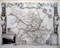 Yorkshire, West Riding Thomas Moule c1845 - 28 x 22 cm Decorative map with vignettes and coats of arms. Uncoloured as issued. Single original fold. Very good margins for a Thomas Moule. A few spots of foxing at the RHS. Several railways are shown. Larger image Ref uk1096 : £18 Return to Great Britain & Ireland Index |
 Yorkshire, West Riding (S) Archer for Dugdale 1850 - 24 x 18 cm Very fine outline hand colouring of the County and Hundred boundaries as well as the railways which are a feature of these attractive maps Larger image Ref uk339 : £8 Return to Great Britain & Ireland Index |
 Yorkshire: 4 sheets Edward Weller 1858 - 42 x 30 ea. 85 x 60 when joined together cm Original outline colour. A large map for the Weekly Dispatch Atlas. Mount all four together to form one large map. N E Map: Small rust mark in sea. N W and S W Maps: have double crease diagonally through them. S W Map has similar rust mark to NE sheet. Central East West creases. Four images available. Larger image 1 : Larger Image 2 : Larger Image 3 : Larger Image 4 Ref uk200 : £32 Return to Great Britain & Ireland Index |
 Yorkshire: 4 sheets G W Bacon 1887 - 84 x 61 cm Large four page hand coloured map as issued with woods, parks, hills, roads and railways. The railway companies are named on each line. Mount the four sheets together to form one very large map. The North West sheet has been repaired on the front with transparent water based tape at the bottom of the centrefold but when joined as a large map only 3 mm would be exposed and hardly perceptible. Four images available. Larger image 1 : Larger Image 2 : Larger Image 3 : Larger Image 4 Ref uk545 : £30 Return to Great Britain & Ireland Index |
 Yorkshire: 4 sheets G W Bacon 1897 - 84 x 61 cm Large four page coloured map with woods, parks, hills, roads and railways. The railway companies are named on each line. Mount the four sheets together to form one very large map. Good condition. Four images available. Larger image 1 : Larger Image 2 : Larger Image 3 : Larger Image 4 Ref uk546 : £25 Return to Great Britain & Ireland Index |
 Yorkshire: 4 sheets G W Bacon 1898 - 84 x 61 cm Large four page coloured map with woods, parks, hills, roads and railways. The railway companies are named on each line. Mount the four sheets together to form one very large map. The outer margins rather stained but when joined and mounted would look very good. Four images available. Larger image 1 : Larger Image 2 : Larger Image 3 : Larger Image 4 Ref uk547 : £22 Return to Great Britain & Ireland Index |
> Section 1 > Section 2 > Section 3 | |||