| Home Page | Buying | Maps | Books | Prints | Ephemera |
- Home Page
- Australia
- New Zealand
- Pacific Islands and Australasia

1,500 maps reduced in price
All our maps are Originals, NOT modern reproductions
Now all our maps have thumbnails as well as larger images so finding what you want is quicker.
If you want several items, email me for a discount!
Email: don@theoldmapman.com
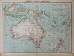 Australasia - Industries and Communications Geo. Philip c1907 - 48 x 35 cm Very large coloured map of Australasia showing Trade Routes and Railways including the route of a proposed railway from Oodnadatta to Pine Creek near Port Darwin. Sources of minerals and products, especially animal products, shown. Larger image Ref a47a : £12 Return to Australasia Index |
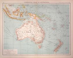 Australasia, Commercial chart Bartholomew, the Twentieth Century Citizens Atlas c1910 - 42 x 32 cm Shows railways, canals, submarine cables and telegraphs and routes to the Pacific Islands. Larger image Ref a76 : £8 Return to Australasia Index |
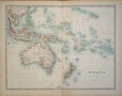 Oceania A K & G H Johnston 1904 - 43 x 32 cm A fine large double page map coloured in outline in the style of Johnston's earlier hand coloured editions. Especially good of Micronesia and Polynesia. Larger image Ref a68 : £9 Return to Australasia Index |
|
| |||