| Home Page | Buying | Maps | Books | Prints | Ephemera |

1,500 maps reduced in price
All our maps are Originals, NOT modern reproductions
Now all our maps have thumbnails as well as larger images so finding what you want is quicker.
If you want several items, email me for a discount!
Email: don@theoldmapman.com
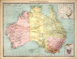 Australia Geo. Philip c1907 - 48 x 35 cm Very large coloured map of the whole of Australia with an inset of Tasmania and a Population Map. The map tends to emphasise the limited amount of the continent that has been developed and the gaps in the knowledge of the interior. Larger image Ref a48 : £10 Return to Australasia Index |
 Australia A K & G H Johnston 1904 - 43 x 33 cm A fine large double page map coloured in outline in the style of Johnston's earlier hand coloured editions. Explorers' tracks criss-cross the centre of the continent Lakes MacKay, Wills and Gregory are not yet shown. Lakes Mcdonald and Amadeus are still shown with conjectured outlines. Larger image Ref a50 : £10 Return to Australasia Index |
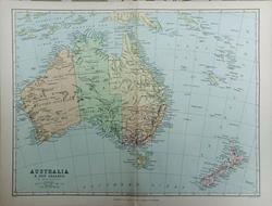 Australia, New Zealand & Islands Adjacent Blackie & Son c1880 - 29.5 x 22 cm Coloured map of the continent showing some ranges in the Western Desert but it does not show the route of the telegraph cable from landfall nr Darwin to South Australia (1870-72) or the Western extension (1877). Nevertheless with a rather more doubtful Lake Amadeus than earlier maps I would go for the 1880 date. Centrefold as issued. 6 pp article included. Larger image Ref a87 : £12 Return to Australasia Index |
 Eastern Australia A K & G H Johnston 1904 - 33 x 43 cm A fine large double page map coloured in outline in the style of Johnston's earlier hand coloured editions which covers Victoria, New South Wales, most of Queensland & part of North and South Australia Larger image Ref a51 : £10 Return to Australasia Index |
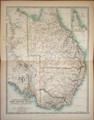
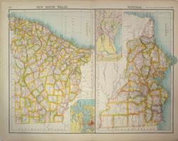
 New South Wales G W Bacon 1907 - 47 x 31 cm Large double page map of New South Wales with an inset of Sydney and Port Jackson which shows depths of the Sound. Some of the Districts appear to be without a settlement of any size. A little spotting in the lower margin, see image. Larger image Ref a53 : £9 Return to Australasia Index |
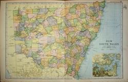
 New South Wales with Victoria Bartholomew, the Twentieth Century Citizens Atlas c1910 - 32 x 44 cm The two maps show many tiny townships and the contrasting empty areas at the time. There are insets of Sydney and the harbour areas and of the Melbourne area with many streets being named. Larger image Ref a77 : £9 Return to Australasia Index |
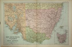 New South Wales, Victoria & pt of South Australia G W Bacon 1908 - 48 x 31.5 cm A detailed coloured map of South Eastern Australia with an inset of Tasmania on the same scale. It shows numerous townships and the railways across the Territories. A little chipped at the edge of the lower margin. Larger image Ref a73 : £9 Return to Australasia Index |
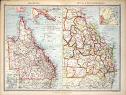 Queensland Geo. Philip c1907 - 48 x 35 cm Very large coloured map of the territory in Counties on one page with inset of British New Guinea. More detailed map of the South-Eastern part on the other page shows railways and a lot of detail with inset of Brisbane River. Larger image Ref a45 : £10 Return to Australasia Index |
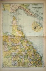 Queensland G W Bacon 1907 - 31 x 47 cm Large double page map of Queensland with an inset plan of Brisbane. The limited railway network is shown. Larger image Ref a57 : £9 Return to Australasia Index |
 South Australia G W Bacon 1907 - 23 x 31 cm Nice full page map of South Australia with an inset plan of Adelaide. Good coverage of the region of lakes North of Eyres Peninsula. Larger image Ref a56 : £7 Return to Australasia Index |
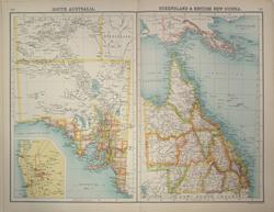 South Australia with Queensland and British New Guinea Bartholomew, the Twentieth Century Citizens Atlas c1910 - 43 x 32 cm The two territories shown side by side with an inset of the area around Adelaide. What is striking about this map is the detail of the river courses to the North-West of Lake Eyre. Larger image Ref a78 : £8 Return to Australasia Index |
 South-East Australia Geo. Philip c1907 - 48 x 35 cm Very large coloured map of New South Wales, Victoria and South Australia, East of Spencer Gulf. The Counties and communication routes clearly shown. Insets of Port Adelaide, Port Jackson and Port Phillip Larger image Ref a46 : £10 Return to Australasia Index |
 Tasmania G W Bacon 1907 - 31 x 47 cm Large double page map of Tasmania and the Furneaux Group of islands. Very clear details of the railway network, the Districts and the physical features. Larger image Ref a58 : £9 Return to Australasia Index |
 Victoria G W Bacon 1907 - 47 x 31 cm Large double page map of Victoria with an inset plan of Melbourne. Very clear details of the railway network. A little spotting in the lower margin, see image. Larger image Ref a54 : £9 Return to Australasia Index |
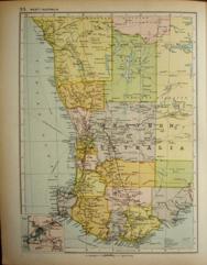 Western Australia G W Bacon 1907 - 23 x 31 cm Nice full page map of Western Australia with an small inset of environs of Perth. Larger image Ref a55 : £7 Return to Australasia Index |
|
| |||