| Home Page | Buying | Maps | Books | Prints | Ephemera |

1,500 maps reduced in price
All our maps are Originals, NOT modern reproductions
Now all our maps have thumbnails as well as larger images so finding what you want is quicker.
If you want several items, email me for a discount!
Email: don@theoldmapman.com
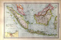 Borneo, Sumatra and Java Geo. Philip c1907 - 35 x 23 cm Large coloured map of the larger islands of East Indies as far East as the Western extremes of Celebes. Inset of the Bay of Batavia, Java. Larger image Ref as95 : £9 Return to Asia Index |
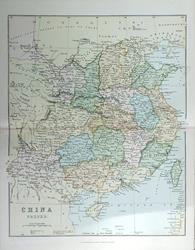 China Bartholomew; W & R Chambers 1868 - 26 x 22 cm An original antique coloured map with centrefold. Larger image Ref as126 : £7 Return to Asia Index |
 China Proper Anon c 1875 - 23 x 29 cm Divided into Provinces. Very nice printed colour with outlines highlighted. Larger image Ref as12 : £9 Return to Asia Index |
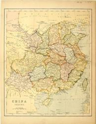
 China Proper Wm MacKenzie c1880 - 23 x 28 cm An original antique coloured map with centrefold. Larger image Ref as127 : £8 Return to Asia Index |
 Chinese Empire & Japan Bartholomew; Wm Collins c1875 - 30 X 23 cm An original antique coloured map with centrefold. Larger image Ref as131 : £8 Return to Asia Index |
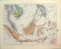 East Indies Ed. Stanford 1882 - 34 x 26 cm A fine coloured map of the mostly Dutch settlements but also showing Siam, Cochin-China, the Philippines, the Malay Peninsula, etc. Larger image Ref as71 : £16 Return to Asia Index |
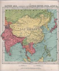 Eastern Asia Bartholomew 1866 - 22 x 24 cm Chinese Empire, India, Japan, etc. Printed colour. Larger image Ref as11 : £9 Return to Asia Index |
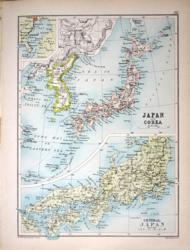
 Islands of Japan and Corea. Verso: Environs of Tokio and Peking W & A K Johnston 1897 - 20 x 26 cm Each island edged in a different colour with a large inset of the Corean peninsular with its multiple islets. Verso: Environs of Tokio and Peking. Two images available. Larger image 1 : Larger Image 2 Ref as30 : £10 Return to Asia Index |
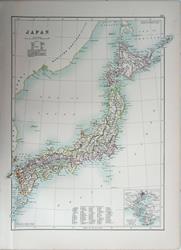 Japan Adam and Charles Black's General Atlas of the World. 1895 - 29 x 39 cm Large coloured map, elegantly coloured in outline. Inset of Tokio environs. Larger image Ref as120 : £11 Return to Asia Index |
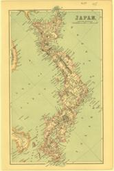 Japan Anon 1885 - 15 x 24 cm Subtle outline colouring and the mountains in relief of the whole chain of islands. Larger image Ref as29 : £8 Return to Asia Index |
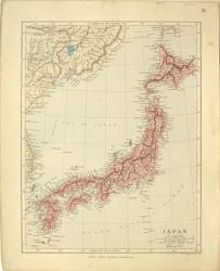 Japan Ed.Stanford 1882 - 25 x 33 cm The country shown divided into administrative districts with some hand wash colour and showing its relation to the Maritime Province of the Russian Empire. Larger image Ref as31 : £15 Return to Asia Index |
 Japan and Corea. Verso: Political Map of Africa Bartholomew c 1895 - 17 x 24 cm Large inset of Central Japan and small inset of the Bay of Tokio. Verso: Africa with the countries outlined in colour. The strong European control is clearly seen. Along with two sections across the continent. Two images available. Larger image 1 : Larger Image 2 Ref as90 : £10 Return to Asia Index |
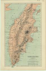 Kamchatka Peterman 1886 - 14 x 24 cm Coloured map showing its volcanic origins in the relief view of the mountains, hot springs and lava. Larger image Ref as32 : £7 Return to Asia Index |
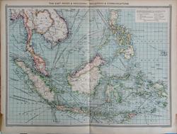 The East Indies, Industries and Communications Geo. Philip c1907 - 48 x 35 cm Very large coloured map of the East Indies, the Malay Peninsula and Indo-China, showing Trade Routes. Sources of minerals and crops shown. These include Gutta Percha, Feathers, Spices, Sago and Birds-nests! Stain in lower corners of margin (see image). Larger image Ref as97a : £12 Return to Asia Index |
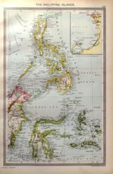 The Philippine Islands Geo. Philip c1907 - 23 x 35 cm Large coloured map of the Philippines, Celebes and the Moluccas with British North Borneo. Inset of Manila Bay. Larger image Ref as96 : £9 Return to Asia Index |
|
| |||